- Published on
Commercial Real Estate Drone Video: Showing a Property at Full Scale

Ground photography has a ceiling — literally. A wide-angle lens at eye level can make a retail strip look tidy or a warehouse look clean, but it can't show a broker's client the truck court depth, the highway frontage, the parking ratio, or where the property sits relative to the interchange two miles north. For commercial real estate, those are the details that move a deal. Scale, access, and context aren't nice-to-haves. They're the deciding factors.
That's the gap commercial real estate drone video fills. Not prettier pictures — better information, delivered from the only vantage point that shows a property the way it actually functions: from above, at full scale.
What Aerial Video Communicates That Ground Footage Can't
A CRE buyer or tenant evaluating a property is asking a specific set of questions. How big is it, really? How do you get in and out? What's around it? Where do the sight lines fall? Aerial video answers all four in a single continuous shot, which is something a deck full of stills can only approximate.
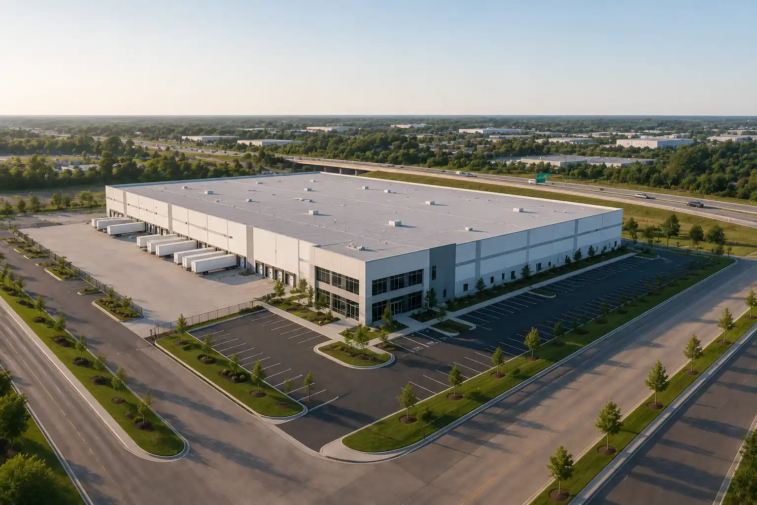
Scale. A 200,000-square-foot distribution center reads as an abstraction on a spec sheet. Flown from 200 feet, it reads as a footprint — the building, the trailer storage, the staging yard, all in one frame, all in proportion. Buyers stop guessing and start measuring.
Access. Ingress and egress, dock doors, drive aisles, rail spurs, highway on-ramps. A descending flight along the approach route shows exactly how a tenant's trucks or a retailer's customers reach the site. For industrial and logistics assets, access is the value.
Surrounding context. No commercial property exists in isolation. Aerial video places it inside its trade area — the anchor tenants next door, the rooftops within a three-mile radius, the competing centers down the corridor. Context is what turns a building into an investment thesis.
Site lines. Visibility from the road, signage exposure, the angle of approach a driver actually sees. For retail and multifamily, site lines drive traffic and lease-up. Drone footage lets you demonstrate them rather than assert them.
Use Cases by Asset Class
Different commercial properties need the camera to tell different stories. The flight plan should follow the asset.
Industrial & Logistics
Truck courts, trailer parking, dock-high door counts, clear-height context, and proximity to interstate access. A slow orbit establishes the building envelope; a low pass down the truck court shows maneuvering room. For sites near rail or port infrastructure, an elevated wide shot ties the property to the broader freight network in a way no map can.
Retail
Co-tenancy and trade-area visibility are everything. Aerial video shows the anchor lineup, parking field, pad sites, and — critically — the traffic counts implied by the surrounding road network. For a single pad or an outparcel, footage demonstrates road frontage and signage visibility to a prospective tenant in seconds.
Multifamily
Unit count, amenity decks, parking structures, and neighborhood context all in one sweep. For a value-add acquisition, aerial documentation captures the existing condition of roofs, courtyards, and grounds — useful for the investment committee and, later, for tracking the renovation. For lease-up marketing, it sells the lifestyle and the location together.
Land & Development
This is where drone video earns its keep. Raw or entitled land is almost impossible to convey from the ground. Aerial footage shows parcel boundaries, topography, existing access points, utility corridors, and adjacency to existing development. For a developer pitching a site to capital partners or a city, it's the difference between a flat plat map and a clear picture of what the ground can become.

Deliverable Formats That Earn Their Place in the Package
Footage only matters if it lands in the right format for the audience. A leasing brochure, an investor deck, and a broker's listing page each ask something different of the same flight. We plan deliverables around where the asset will be used:
- A 60-to-90-second marketing edit — the cinematic flyover for listing pages, email campaigns, and social, scored and color-graded, built to make a property stand out in a crowded inbox.
- Investor-deck clips — short, captioned segments that drop into a pitch presentation. No music, no flourish — just the scale shot, the access shot, and the context shot, each doing one job for the committee.
- Stills pulled from 4K capture — high-resolution aerial photographs for offering memoranda, flyers, and brochures, framed for print and web.
- Annotated context shots — overlays marking property lines, dimensions, access points, and nearby anchors, turning footage into a navigable site reference.
- Raw and graded 4K masters — the full-resolution files for clients who want to cut their own versions or archive the documentation.
The point isn't volume. It's matching the deliverable to the decision it's meant to support.
From Marketing Asset to Documentation Program
For a listing, a single well-planned shoot does the job. But commercial real estate work has a way of becoming development work — the land sells, the project breaks ground, and suddenly the same site needs a different kind of aerial record.
That's a natural progression, not a new vendor search. The flyover that marketed a development parcel becomes the baseline image for a construction documentation program: recurring flights that track progress from groundbreaking to delivery, feed stakeholder reports, and build a dated visual archive for the project file. The same disciplined capture that sold the site can document the build — orthomosaic mapping, progress overlays, and site-wide records that keep investors, lenders, and partners aligned as the asset takes shape.
If you're marketing land today, it's worth knowing the operator you hire can stay with the project once it's vertical.
Why Aviation-Grade Execution Matters Here
Commercial properties tend to sit in more complicated airspace than a suburban listing — near highways, rail, ports, stadiums, and controlled airspace around regional airports. Capturing them legally and safely isn't a given. Every Cascade Flight mission is flown by FAA Part 107-certified, fully insured pilots, with airspace authorization and a pre-flight risk assessment handled before anyone leaves the ground. For a broker putting an institutional asset in front of institutional buyers, that compliance isn't a detail — it's the baseline that keeps your marketing clean and your client's name off any liability.
Hiring an unlicensed operator to save a few dollars on a multimillion-dollar listing is a poor trade. The footage might look fine. The exposure underneath it isn't.
Show the Property the Way It Actually Works
A commercial property is a system — scale, access, context, and sight lines working together or not. Ground photography shows you fragments. Aerial video shows you the system. For brokers, developers, and investors, that's not a marketing upgrade. It's a clearer answer to the questions every buyer is already asking.
Cascade Flight provides commercial real estate drone video and photography across Portland, the Pacific Northwest, and nationwide for larger engagements. If you have a listing, an acquisition, or a development site that needs to be seen at full scale, request a consultation or explore our Real Estate and Aerial Photography services.