- Published on
Drone Surveying for Construction in Multnomah County: A Practical Guide

A tape measure and a tripod-mounted total station still have their place on a job site. But when a Multnomah County GC needs to know how much fill moved last month, where the grade sits against design, or whether the framing matches the plan a lender is about to fund against, those tools are slow, partial, and expensive to repeat. Drone surveying answers the same questions faster, across the whole site, and on a schedule you can actually keep.
This is a practical guide to what construction drone mapping delivers, how it fits the realities of building in Multnomah County, and what to have ready before the first flight.
What Drone Surveying Actually Delivers
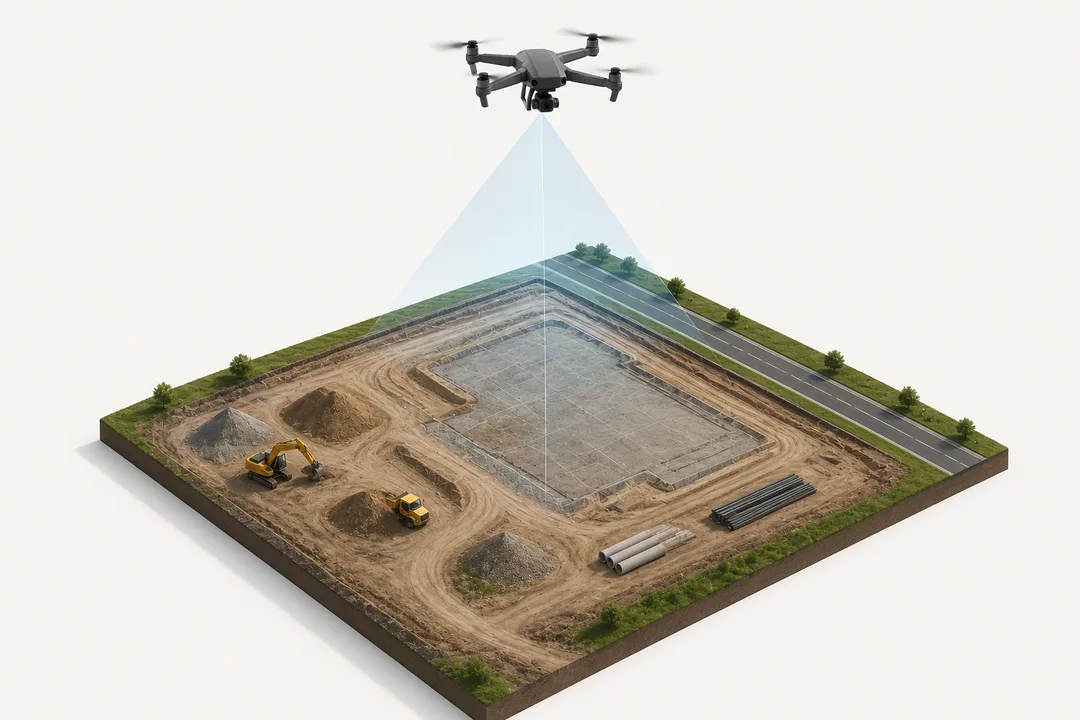
"Drone surveying" is a catch-all for several distinct deliverables. Each answers a different question, and knowing which one you need is the difference between useful data and an expensive video.
Orthomosaics. Hundreds of overlapping aerial images stitched into a single, distortion-corrected, georeferenced map of the entire site. Unlike a regular photo, an orthomosaic is measurable — you can pull distances and areas directly off it. It's the base layer most construction documentation is built on.
Topographic surveys. Elevation data captured across the site and turned into contour maps, surface models, and existing-condition baselines. For sitework, grading, and drainage planning, a drone topo gives civil engineers a dense, current surface in a fraction of the time a ground crew needs to walk it.
Progress documentation. Dated, repeatable flights flown from the same flight plan, producing a consistent visual and spatial record from groundbreaking to closeout. Overlay this month against last month and the progress — or the slippage — is impossible to argue with.
Volumetrics. Cut-and-fill calculations, stockpile measurements, and earthwork tracking derived from the survey data. Instead of estimating how much material is on site or how much has moved, you measure it. That matters for pay applications, for reconciling against the grading plan, and for catching a discrepancy before it becomes a change order.
Together these turn aerial capture into something a project team can act on: a measurable, dated, site-wide record that supports reporting, billing, and decisions.


Why This Matters Specifically in Multnomah County
Building in Multnomah County is not building anywhere. The county runs from dense urban Portland infill through Gresham, Troutdale, Fairview, Wood Village, and out to Corbett and the Columbia River Gorge — tight lots and constrained staging in the city, larger sitework and grading-heavy projects toward the county's eastern edge. Drone surveying flexes across both.
On a constrained Portland infill site, repeatable aerial documentation gives you a clean record of conditions when you can't get a clear ground-level vantage and neighbors are close. On a grading-heavy development out toward Gresham or Troutdale, volumetrics and topo become the daily tools — tracking earthwork, reconciling against the design surface, and keeping the dirt balanced.
There's a reporting dimension too. Development in the county runs through real review and permitting processes, and stakeholders — owners, lenders, public agencies, neighborhood review — increasingly expect documentation, not assertions. A dated orthomosaic or progress set is a clean, defensible record of existing conditions and as-built progress, the kind of evidence that shortens disputes and strengthens a reporting package. It's the difference between telling a stakeholder the site is on track and showing them.
Airspace is the other local reality. Much of urban Multnomah County sits under controlled airspace tied to PDX and surrounding operations. Flying a construction survey legally here means securing LAANC authorization or the appropriate waiver before takeoff — not something a hobbyist with a consumer drone reliably handles. Every Cascade Flight mission is flown by FAA Part 107 certified, fully insured pilots, with airspace authorization and a documented pre-flight risk assessment handled as part of the job, not as an afterthought.
What to Have Ready Before the First Flight
Better planning produces better data. Before scheduling a construction survey flight, it helps to define a few things up front:
- The decision the data supports. Pay-app volumetrics, a grading baseline, a monthly owner report, and a lender progress record are different deliverables. Name the use and the capture is built around it.
- Survey-grade accuracy needs. If the data feeds engineering or design, ground control points or RTK/PPK workflows may be required to hit tolerance. Flag that early — it changes how the flight is flown.
- Site control and existing data. Share any existing survey, design surface, or control network so deliverables tie cleanly to your coordinate system.
- Cadence. A one-time topo is a single mission. Progress documentation is a recurring program flown on a fixed interval — weekly, biweekly, or tied to milestones — and it works best scheduled from the start.
- Access and timing. Site activity, weather windows, and the county's seasonal conditions all shape scheduling. Booking ahead beats scrambling around a rain day.
The Documentation Becomes an Asset Over Time
A single survey solves a single problem. A documentation program compounds. Flown consistently across the life of a project, drone surveying builds a dated archive that follows the build from raw ground to final delivery — a record that pays off at every pay application, every stakeholder meeting, every dispute, and ultimately in the as-built file. For GCs and developers running multiple projects across the metro, that consistency is what turns aerial capture from a one-off line item into a standard part of how the work gets documented.
Get a Survey Plan Built Around Your Site
Drone surveying for construction isn't about footage. It's about measurable, dated, defensible documentation that helps a project team see the site clearly and keep everyone aligned — owners, engineers, lenders, and the county alike.
Cascade Flight provides construction drone mapping and surveying across Portland, Gresham, Troutdale, Fairview, Wood Village, Maywood Park, Corbett, and the wider Pacific Northwest. To scope a one-time survey or a recurring documentation program, request a consultation, explore our Construction services, or see our Multnomah County commercial drone services.